Validation of Atmospheric Instability Indices from Himawari-9 Against Radiosonde Observations
DOI:
https://doi.org/10.30736/seaj.v7i1.1166Keywords:
Himawari-9, Radiosonde Observations, Atmospheric Instability Indices, ValidationAbstract
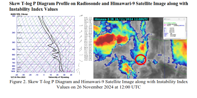
Validation of Atmospheric Instability Indices from Himawari-9 Against Radiosonde Observations. Remote sensing is crucial in measuring atmospheric instability by providing continuous spatial and temporal observations, often through satellite-based retrieval algorithms and numerical models. This study evaluates atmospheric instability indices derived from Numerical Weather Prediction (NWP) models using Himawari-9 satellite data. The results are compared with Radiosonde observations at the Tunggal Wulung Meteorological Observation Post, Cilacap, Central Java. The observation period includes four-time samples of Radiosonde observations identified with essential weather events. Atmospheric instability indices such as Showalter Index (SI), Lifting Index (LI), K Index (KI), Severe Weather Threat (SWEAT), and Convective Available Potential Energy (CAPE) are used to analyze the dynamics of atmospheric instability that trigger important weather events such as rain. The research method involves processing Radiosonde observation data provided by Wyoming and satellite imagery using GMLSPD software. The results of this study reveal cloud images and instability index values that explain the occurrence of essential weather events with a moderate category. Although some parameter values differ from Radiosonde data, the NWP-GSM indices from Himawari-9 are in good agreement with Radiosonde measurements for certain instability index categories. These findings suggest that Himawari-9 GSM can complement and be an alternative to Radiosonde observations by providing continuous atmospheric instability analysis, especially during periods without Radiosonde measurements. This shows its potential to improve weather monitoring and forecasting. However, further research such as high computing power, seasonal pattern analysis, and reducing errors such as parallax errors are still needed to maximize the findings.
Downloads
References
Ali, A., Deranadyan, G., & Sa’adah, U. (2021). Kajian awal pemanfaatan data pengindraan jauh dalam implementasi peringatan dini cuaca esktrem berbasis dampak. Prosiding WIN-ID, 1, 27-36.
Ando, R., Watanabe, S., Murata, K. T., dan Kunakornvong, P. (2020). Exploration of the earth's environment using “Himawari-8” data from meteorological satellites and deep learning. Jurnal Penelitian RMUTR Bangkok, 14(2), 1-9. https://ph02.tci-thaijo.org/index.php/rmutk/article/view/240210
Athoillah, I., Dewi, S., & Renggono, F. (2016). Perbandingan Pengukuran Radiometer dan Radiosonde pada Musim Hujan di Dramaga Bogor. Jurnal Sains & Teknologi Modifikasi Cuaca, 17(2), 75. https://doi.org/10.29122/jstmc.v17i2.640
Downloads
Published
How to Cite
Issue
Section
License
Copyright (c) 2025 Rayhan Rafi, Roihan Fauzi Citra, Delfiana Yoventa Buti

This work is licensed under a Creative Commons Attribution-ShareAlike 4.0 International License.
Authors who publish with this journal agree to the following terms:
- Authors retain copyright and grant the journal right of first publication with the work simultaneously licensed under a Creative Commons Attribution-ShareAlike 4.0 International License that allows others to share the work with an acknowledgment of the work's authorship and initial publication in this journal.
- Authors are able to enter into separate, additional contractual arrangements for the non-exclusive distribution of the journal's published version of the work (e.g., post it to an institutional repository or publish it in a book), with an acknowledgment of its initial publication in this journal.
- Authors are permitted and encouraged to post their work online (e.g., in institutional repositories or on their website) prior to and during the submission process, as it can lead to productive exchanges, as well as earlier and greater citation of published work (See The Effect of Open Access).

This work is licensed under a Creative Commons Attribution-ShareAlike 4.0 International License.